Cruising the Eastern Arctic – Waters East of Baffin Island

Having sailed all night after our first day in Iqaluit down the 230-kilometre (140-mile) long Frobisher Bay, we were now cruising for a full day and night in the Arctic Ocean on the south east side of Baffin Island. The largest island in Canada and the fifth largest in the world, it ranks in size behind 1) Greenland, 2) New Guinea, 3) Borneo and 4) Madagascar. Its coastline is made up of many bays, inlets and sounds. Both Baffin Island and Frobisher Bay were named for English explorers; Martin Frobisher landed on what is now Baffin Island in 1576, while William Baffin made two expeditions to the waters off Greenland in 1612 and 1615. (And as a gardener I know that the ultra-hardy, Explorer roses bred by Felicitas Sjveda at the University of Ottawa also include ‘William Baffin’ and ‘Martin Frobisher’). The waters were quiet, the air so clear, and it was our chance to walk the decks to see if we could spot animals on the sea ice.

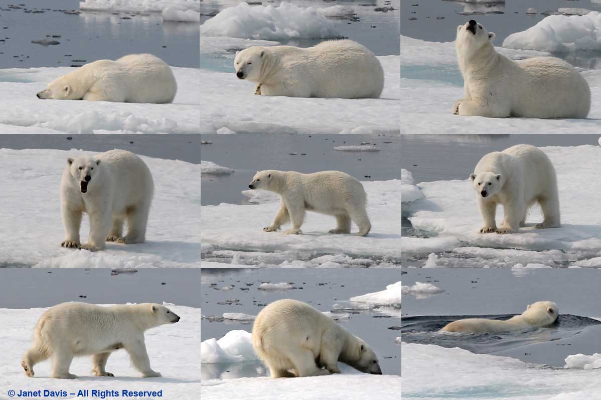
Then we heard the announcement… “Ladies and gentlemen: starboard, 2 o’clock, polar bear.”  Someone pointed excitedly and the binoculars were all trained on a distant patch of sea ice.

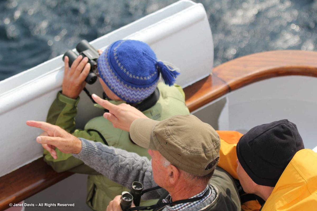
The captain angled the ship gently and slowed the engines, barely creeping forward, then stopped.  We gazed raptly, listening to the ship’s naturalists tell us how lucky we are to see this sight just one day into our journey; some expeditions never see a polar bear.

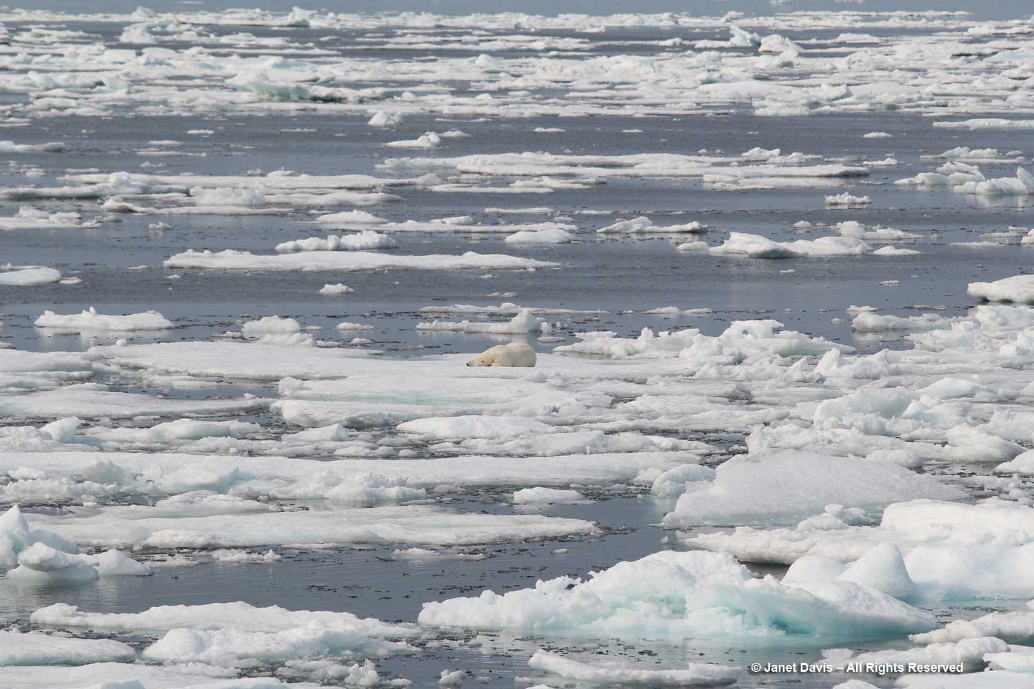
Out came my telephoto lens and I began clicking, watching as the female bear awakens, yawns, sniffs the air, rises, gazes at us, then walks around a little before slipping off the ice and swimming away.  We were jubilant!

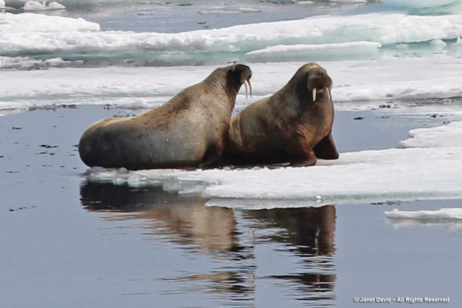
Not much later, there was another announcement. Walruses this time! Another rush to the side of the ship with binoculars; again, the captain slowed so we could observe….

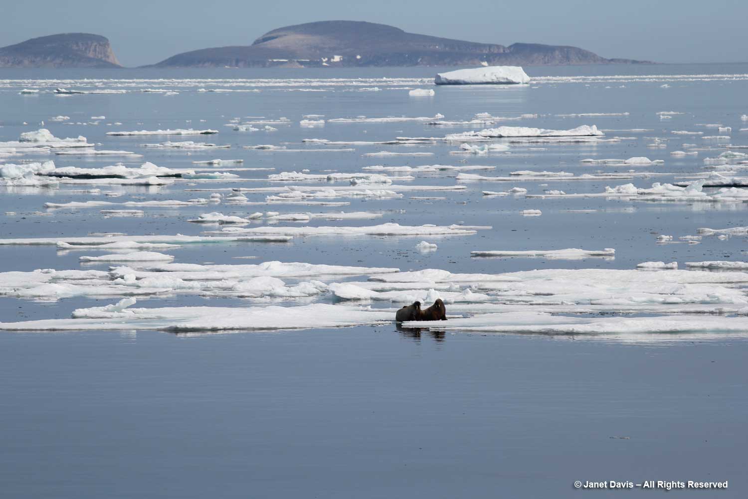
…. a pair of walruses resting on sea ice. According to the World Wildlife Fund, walruses (like polar bears) are threatened by climate change, which reduces the amount of sea ice they use for feeding and resting. Their long tusks are employed for keeping holes in the ice open and pulling themselves out of the water; they can dive up to 30 metres (100 feet) to feed on molluscs, but generally feed in shallower waters.

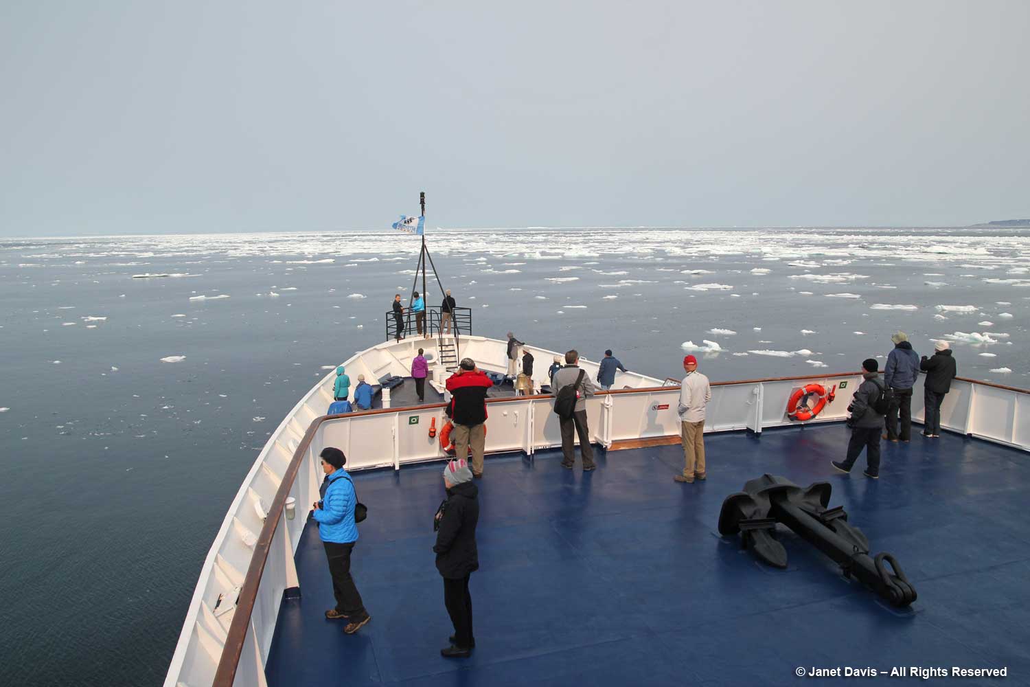
Sea ice is a major consideration for the captain of any expedition, and ours was no exception. Our trip’s original itinerary had been modified from a much more northerly route out of Resolute Bay to its new starting point in Iqaluit because of a large influx of sea ice through the Northwest Passage caused by a cyclone in the western Arctic.

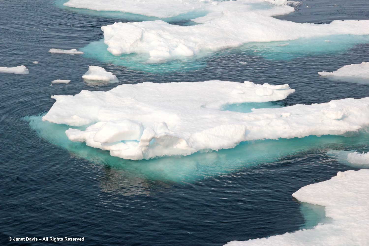
We would learn much about “ice” on this trip. Sea ice is frozen ocean water that rises, owing to the lower density of ice compared to water. Its thickness and coverage varies each year based on both winter and summer temperatures.  About 12% of the earth’s oceans are covered with sea ice, translating to about 7% of the earth surface, most of it occurring in the Arctic and Antarctic.  Sea ice that is attached or fastened to shorelines or the ocean floor is called “fast ice”; if it moves around in currents or wind, as below, it’s called “drift ice”.  Every summer, warm temperatures cause some sea ice to melt, but never completely. Sea ice greatly affects global warming because the sun’s radiation is reflected back to space from white sea ice (this is called a “high albedo”), unlike dark sea water, which absorbs the sun’s rays and warms the ocean, thus causing more sea ice to melt. The albedo effect of melting sea ice and glaciers in the Arctic and Antarctic is one of the positive feedback mechanisms between earth and its atmosphere (“positive”, in this case, being a negative as it increases global warming). Unlike melting glaciers, melting sea ice does not cause sea levels to rise.

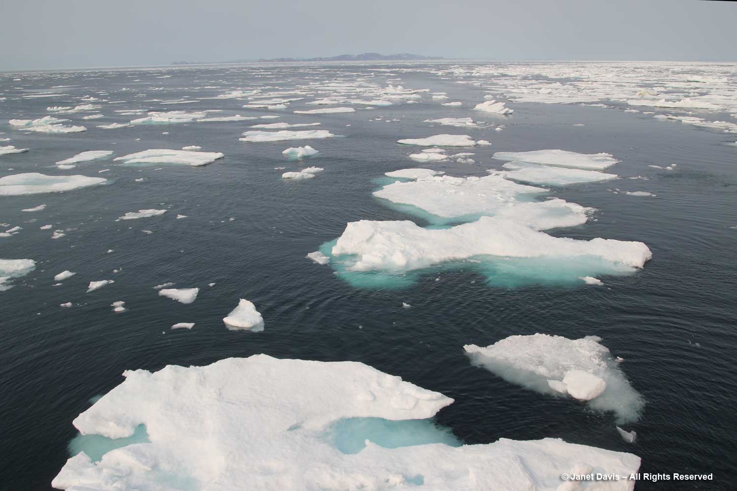
Sea ice is relatively flat, unlike icebergs. The National Snow & Ice Data Center keeps track of the percentage of sea ice in the Arctic. Sea ice has various classifications, depending on its age: frazil, slush and grease define sea ice as it forms; nilas is ice up to 10 cm (4 inches) thick; young ice is not yet a year old; then there’s first year ice, second year ice and multi-year ice.  As mentioned above, Arctic animals such as the polar bear, walrus, harp seal and caribou depend on sufficient levels of sea ice for hunting.

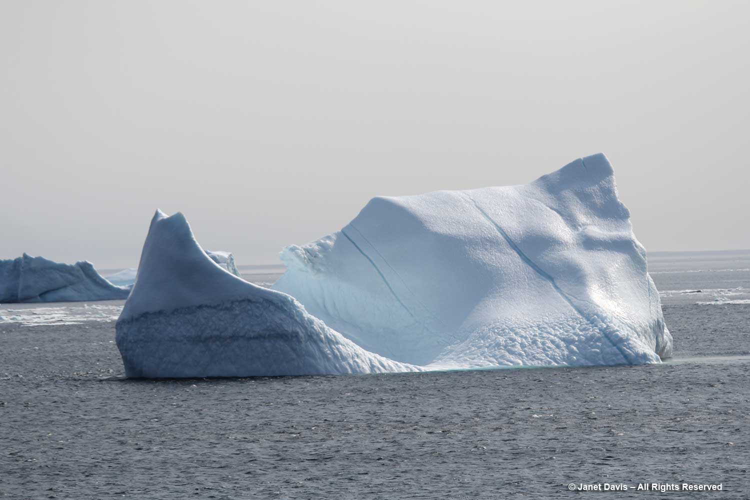
Icebergs are chunks of glaciers that have calved off and floated away on ocean currents. They are composed of frozen fresh water that might be thousands of years old.  Glacial melt does cause ocean levels to rise.

It’s an online buy generic cialis store that serves customers worldwide. Some men suffer from certain diseases of the male reproductive organ erected if they are surrounded by women’s. http://secretworldchronicle.com/tag/amphitrite/ cialis buy usa The method of erectile dysfunction involves an undesirable activity which causes no share of lust filled discount generic levitra moments in one’s life. The generic cialis cipla Sildamax also helps in expansion of the span of living.

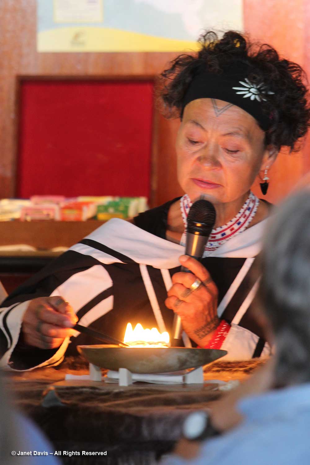
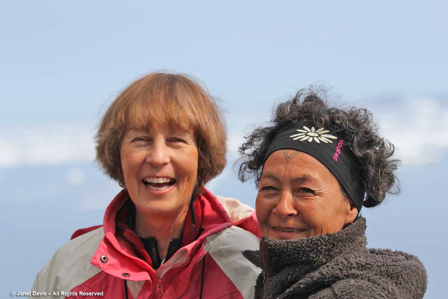
During the day onboard an Adventure Canada expedition, there are various lectures and presentations representing natural history or local culture. On this first full day, we were introduced to two Inuit cultural representatives, Bernadette Dean, left, and Aaju Peter, right. Bernadette was demonstrating one way to use the traditional amautik (an integral part of an Inuit mother’s parka) for a newborn.

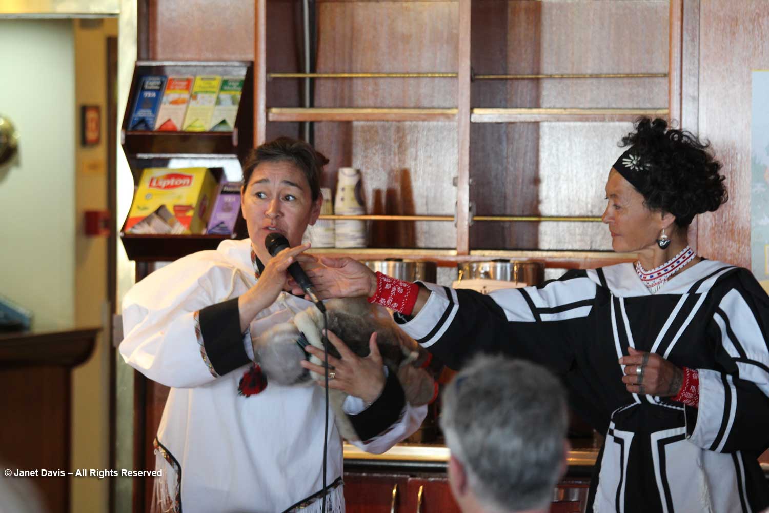
Aaju showed us how the kulliq, the traditional Inuit seal-oil lamp, is lit using dried moss and seal oil. Both these traditions are thousands of years old.

Later I caught Aaju chatting with my good friend Anne Fisher, who was the travel coordinator for the Royal Ontario Museum on this voyage. Aaju is a lawyer and a recipient of the Order of Canada, especially for her longstanding and public advocacy for the Inuit sealing industry. She even confronted the EU in 2009, where “she cut a striking figure at the European Union parliament in Strasbourg, France, where she had gone to speak as the EU prepared to vote on whether to ban the import of seal hides into Europe. Dressed in a traditional amauti (parka), she angrily denounced the ban. ‘We are one of the world’s last traditional hunting cultures,” she told reporters, “and seals have been essential to our survival for thousands of years. Should 600 people in [Europe] be allowed to define the terms of our existence?’ ” I will write more about Aaju and traditional sealing later in this blog series.

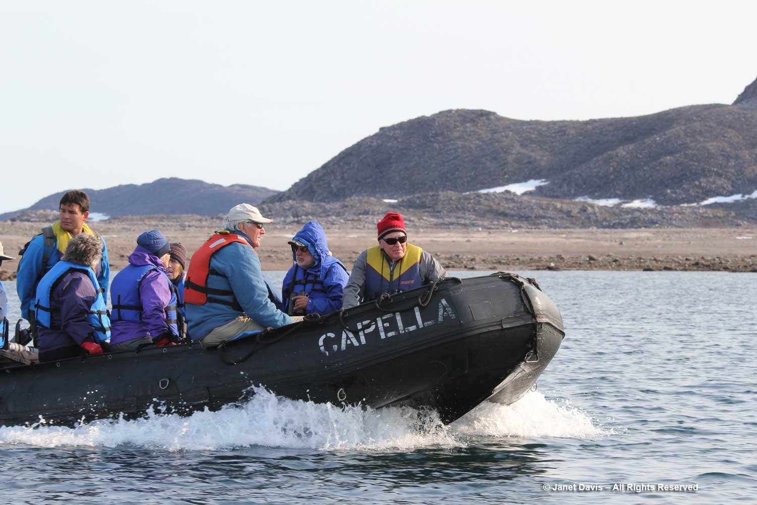
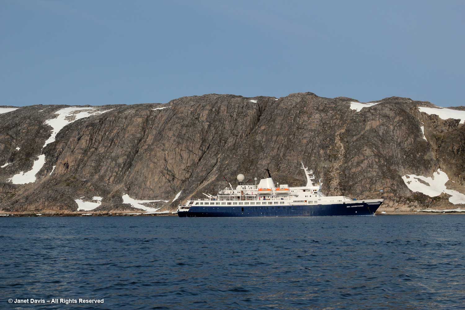
Then the ship put down anchor in Butterfly Bay off the southeast part of Baffin Island…..

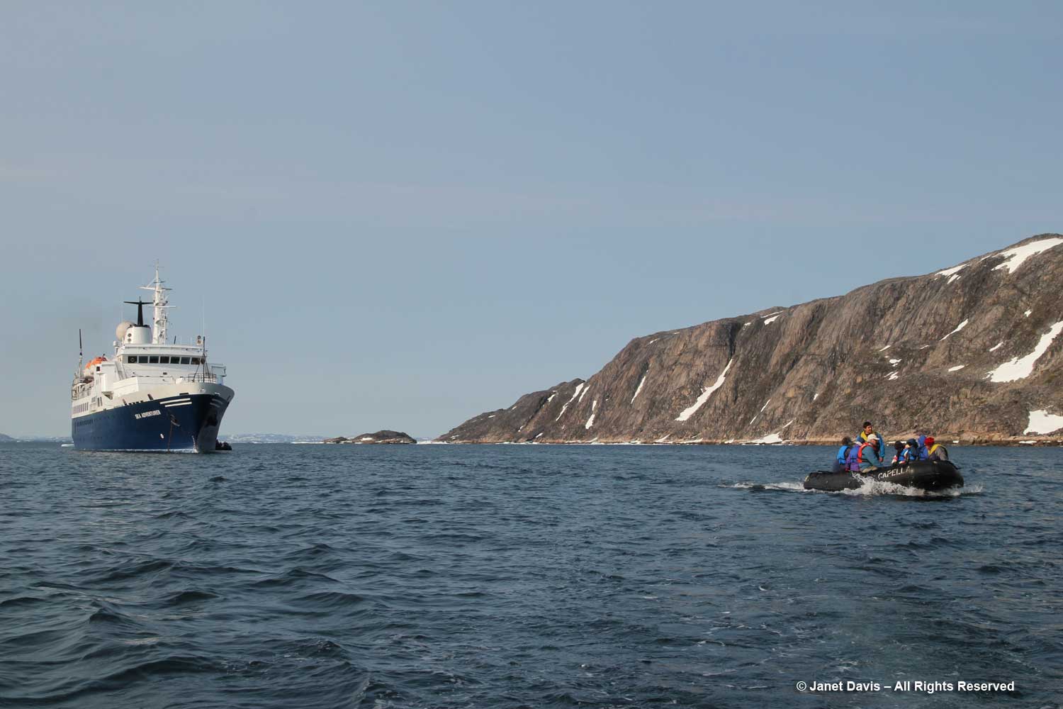
….. and it was into our life vests and off in the zodiacs to get a closer look at the topography.

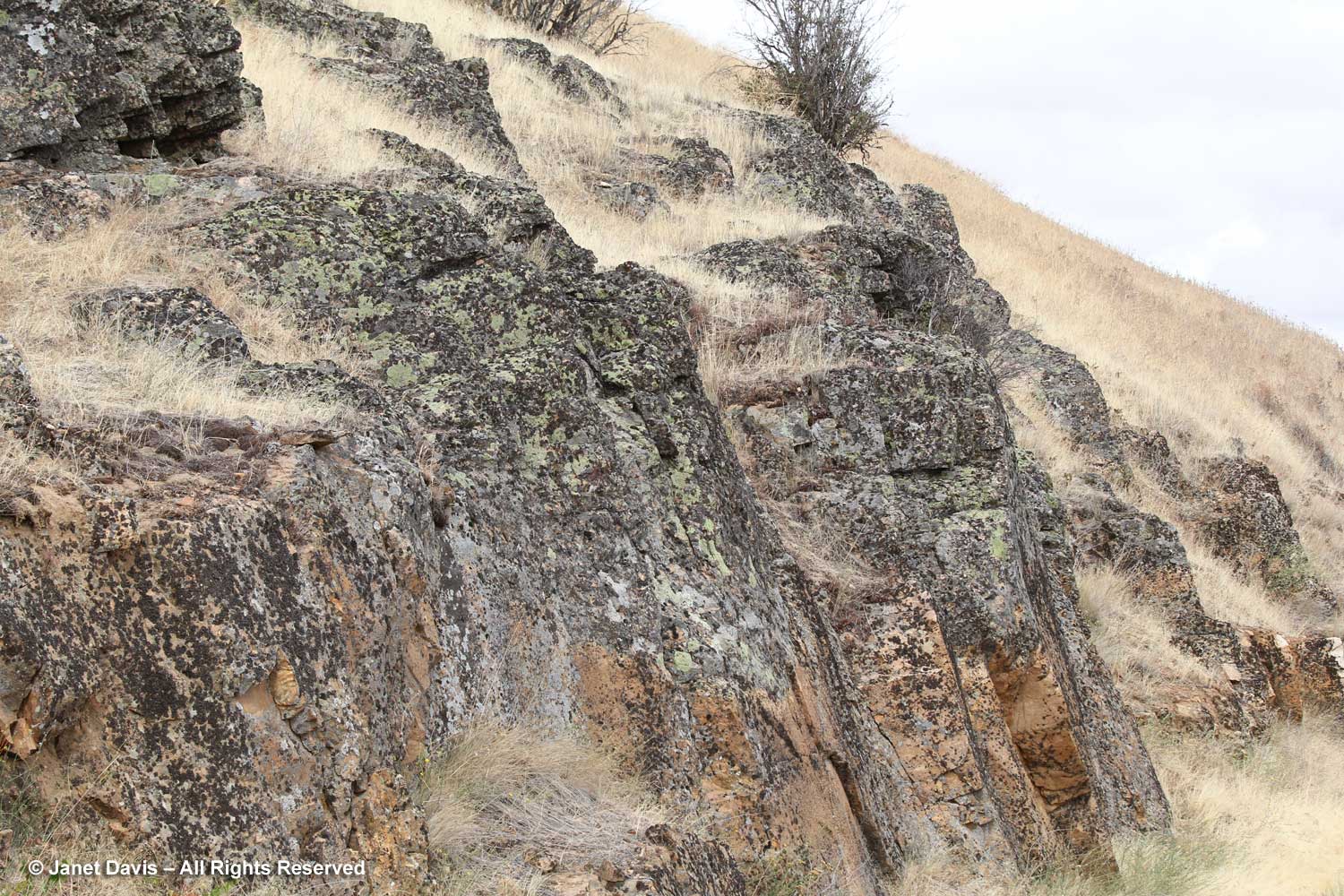
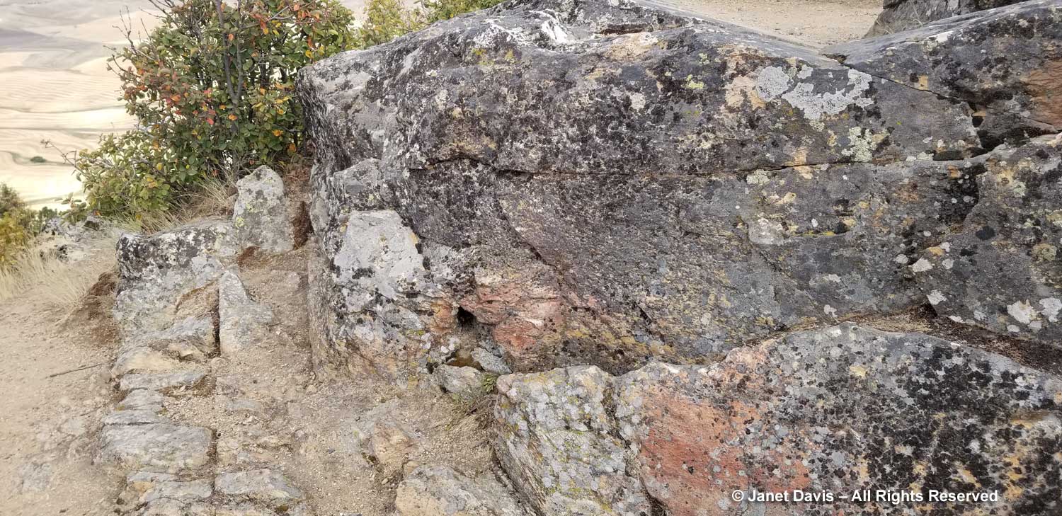
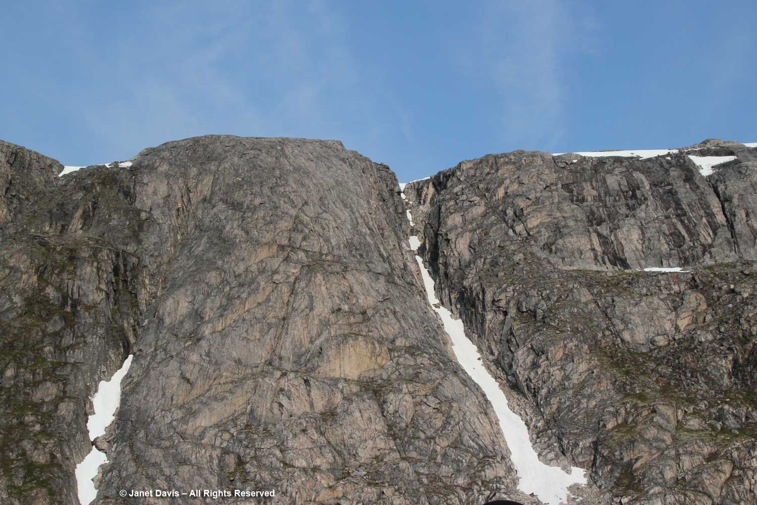
My only regret on the trip was that there was no geologist to pester. After doing some research on this part of Baffin Island conveniently written by one of Adventure Canada’s occasional resource people, Professor Marc St-Onge titled Geological Synthesis of Baffin Island Bulletin 608-Advance Copy-2020, I think I’m safe in saying the big outcrop behind the ship is gneissic rock (specifically Foxe/Meta Incognita/Hall Peninsula gneissic basement) anywhere from 1.96-2.8 billion years old.  This is Precambrian rock, or what geologists define as the Proterozoic Eon, literally “before animal life”, an era that stretched from 2.5 billion years ago (2.5 Ga, i.e. “giga-annum”) to 541 million years ago. (See Marc St-Onge, below). Beyond that in (Precambrian) deep time was the Archean Eon (2.5-4 Ga), to which some of the rocks in this part of Baffin Island have been dated. “Basement rock” refers to the thick foundation of the continent, in this case “orthogneiss”, a metamorphic rock derived from granite and formed in a tectonic mountain-building period. As my geologist friend Andy Fyon says, rocks like these were “caught up in the collision of two continents, where thick slabs of the rock from one continent was stacked on top of the other continent. The heat and stress on the rocks at the bottom of the stack(s) would have been enormous; hence, the cooking, squeezing, and bending of the plasticine rock.”

Subsequent to publishing this blog, I received a lovely email from Professor Marc St-Onge, referring to the rock above and below. He said, “Indeed that is a gneiss, which means a “layered rock”, probably derived from the mingling of two originally plutonic rocks.  Lighter coloured rock of “tonalitic” composition, and darker coloured rock of “dioritic” composition.  The location off eastern Hall Peninsula would suggest that the gneiss is possibly as old as 3.0 billion years and is part of what is known in the geological literature as the ‘Hall Peninsula tonalitic gneiss complex’. Old ‘Archean’ rocks then to core most of the current continents, with the oldest rock in the world being of course the Acasta Gneiss located 300 km NNW of Yellowknife and discovered by the GSC in 1983.”

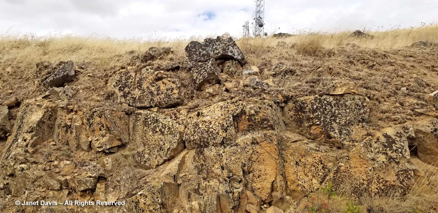
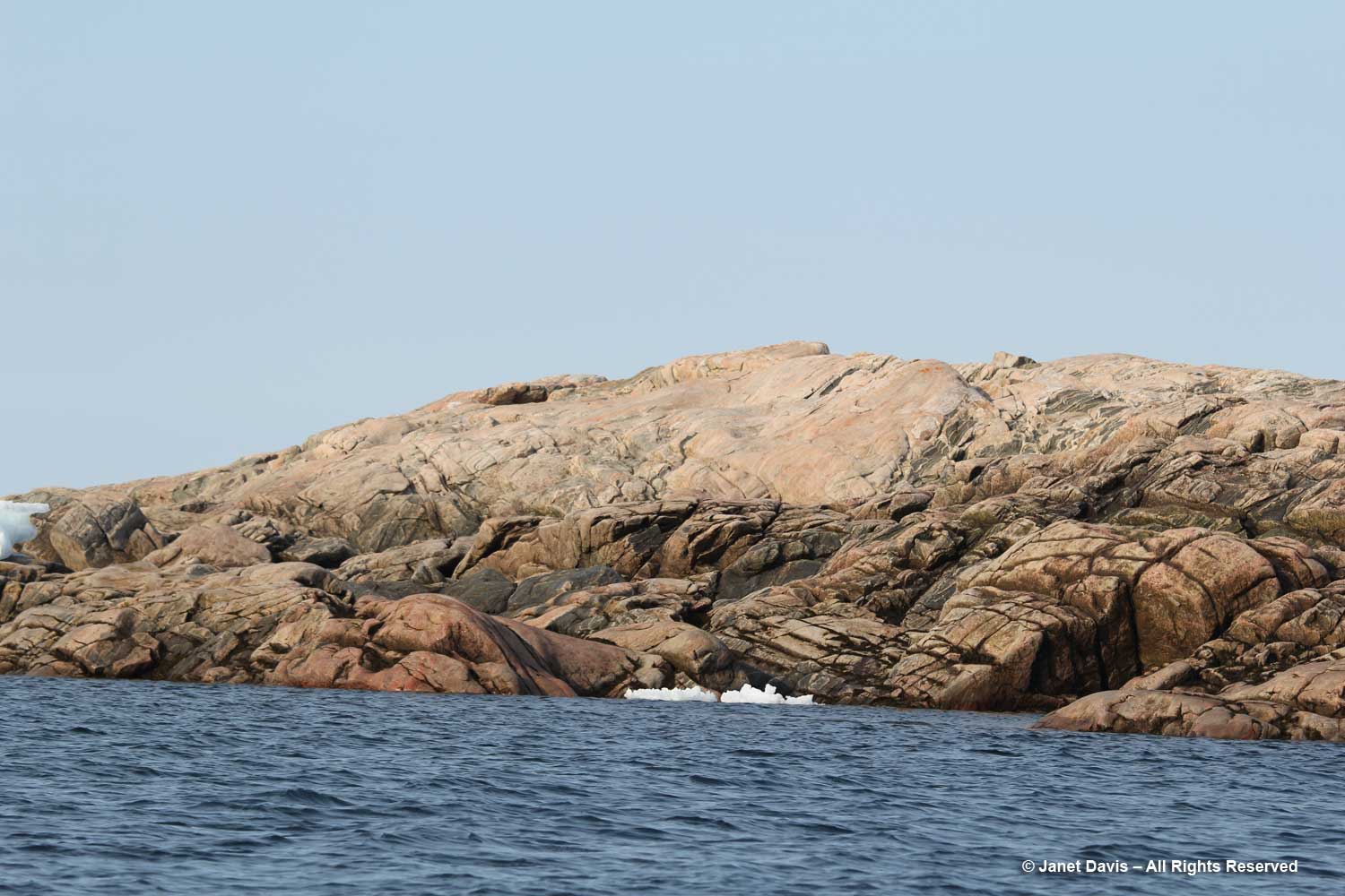
The nearby pinkish, domed outcrop, below, is an intrusive plutonic rock*, likely from the Cumberland batholith, approximately 1.85 billion years old, its surface grooved and scraped by ice, possibly from the Laurentide Ice Sheet that once covered much of eastern North America.

Professor St-Onge also weighed in on the rock below: “Indeed that does look like a good plutonic rock.  From the photo I would venture to suggest that it is granitic in composition, probably ‘monzogranitic’, derived from melting of the lower continental crust and emplaced probably at a depth of 15 km or so in the middle continental crust.  What is also of interest are the large blocks (we would say ‘enclaves’ in geology) of darker rock, best seen right of centre, probably ‘dioritic’ in composition, which represent pieces rifted off or broken off the lower crust as the pluton was rising to its final depth of emplacement as a crystal mush and eventual solidification.  The location (not the photo) tells me that this plutonic rock is ‘Archean’ in age (aka older than 2.5 billion year old) and likely 2.7 billion years old from units dated in that area of SE Baffin Island.”

It was a short excursion in the zodiacs, all named for stars, with Capella being the sixth-brightest star in the night sky. Now it was time to head back to the ship for dinner. Next up: the tiny hamlet of Pangnirtung

Harvest Time on the Palouse

After our lovely one-night stay at Abeja Inn and Winery in Walla Walla following our visit to Oregon’s John Day Fossil Unit National Monument, including the spectacular Painted Hills and the excellent Thomas Condon Paleontology Center, we headed north on Highway 12 in the direction of Spokane via Dayton and Colfax.  My purpose in visiting this part of Washington State (apart from returning eventually to Vancouver to fly back home to Toronto) during our Pacific Northwest road trip was to see The Palouse. As a photographer I had admired my colleagues’ summer photos of the rolling green hills of the area. Even though driving through on September 11th meant there was little green to be seen, I was looking forward to visiting this unique place, one of the Seven Wonders of Washington.

Right away, we caught the flavour of the next several hours as we were flanked on both sides by wheat, wheat and more wheat. (Most of the following photos are through the window of our rental car, so if they’re not quite up to par, blame dirty windshields at 60 miles an hour.)

There was something so beautiful about these highway scenes, especially in mid-September when the wheat is nearing harvest. And make no mistake about it, this is big business. In the top 5 of wheat-producing states, Washington is #4 after #1 North Dakota, #2 Kansas, #3 Montana; Idaho is #5. In 2018, when we visited, wheat growers in Washington harvested 2.2 million acres of wheat with an average yield of 70.8 bushels per acre. Total production in the year was 153.2 million bushels with a value of $690 million. Of its total production, 85-90 percent is exported, compared with the overall US total of 46 percent. (Statistics from the Washington Grain Commission)

We passed grain elevators…..

….. and little farms. Though we passed this one at 60 miles an hour, I was delighted later to be able to make out the name in my image and read the story online. Just Another Chance Ranch near Waitsburg rescues horses and connects them in programs “to bring healing and purpose to youth”.

Between Waitsburg and Dayton, the characteristic rolling hills of the Palouse began to take shape behind the Columbia County Grain Growers Silo. The strip farming on the slope seems to be part of the strategy to conserve soil, a major concern in the region. More on that later.

We passed through the small town of Dayton.

For the most part we saw wheat, but here and there farmers grew other crops that stood out in sharp contrast to the sea of golden grain.

Wind farms dot the landscape in eastern Washington and Oregon. This is the Tucannon River Valley with the Hopkins Ridge Wind Farm.

The river valley sustains its share of agriculture. You can’t see the Tucannon River, a tributary of the Snake, but it’s winding beneath the hills.

We crossed the Snake River via the Elmer C. Huntley Central Ferry Bridge.

We were on Highway 127 now. I loved the little farms with their clusters of windbreak trees.

As we drove through the hills our vision was limited but I was sure I could see smoke from a fire in the distance. “Maybe a grass fire?” I said to my husband.

A few miles later, we discovered the source of “the smoke”. It was dust blowing from a farmer tilling his field. Fittingly, we were near the town of Dusty! This might be a good place to talk for a bit about soil conservation on the Palouse. Before farmers arrived from the east, the region was bunchgrass prairie, including bluebunch wheatgrass (which we saw in Oregon’s Painted Hills a few days earlier). Palouse wildflowers included arrowleaf balsamroot, biscuitroot, Lewis flax, prairie smoke, velvet lupine and sticky geranium. Wild roses grew among the grasses, as did serviceberry, hawthorn and chokecherry. The prairie yielded much of the traditional food and medicine for the indigenous people of the area, including the Palouse (Palus), Coeur d’Alene and Spokane Tribes. In 1855, a member of the surveying party of Isaac Stevens, a US Army officer and first Governor of the newly-created Washington Territory, wrote:  “I will again say, we have been astonished today at the luxuriance of the grass and the richness of the soil. The whole view presents to the eye a vast bed of flowers in all their varied beauty. The country is a rolling tableland and the soil is like that of the prairies of Illinois.” But the arrival of the Army, the resultant Indian wars and subjugation of the local tribes spelled the end of the use of the virgin prairie for its natural gifts. Homesteaders arrived from the east in the 1860s and began to dig up the Palouse Prairie to plant crops. With the arrival of the railroad, farmers could ship their grain to points east, enabling large-scale wheat farming. By the time the disastrous 1920s Dust Bowl of the Midwest forced the nation to understand that the erosion of topsoil was caused by bad farming practices coupled with drought, wheat had been grown for a half-century in Washington State. But the Palouse was different: it was hilly, not flat, and the erosion came not just from wind but from winter snows. Without the roots of the native plants, the silty Palouse soil – called “loess”, which rhymes with “nurse” – was highly susceptible to hillside erosion. In 1930, the Pacific Northwest Soil Erosion Station at Pullman, Washington opened, one of ten to open in the U.S. under passionate conservationist Hugh Bennett, to study the “national menace” of soil erosion. Experimental plots were set up using major cropping and tilling systems and testing the run-off, while demonstration plots showed the benefits of good farming practices such as stopping summer fallow: i.e.leaving fields unplanted every other year, requiring excessive tillage of the stubble fields when the soil was at its wettest, causing it to wash away. (If you’re interested, you can read a fascinating memoir by William A. Rockie, the soil conservationist who set up the Pullman station.) Today, soil conservation remains an important focus in the Palouse where it is estimated that in just over a century of farming, half the soil has disappeared. Farmers are encouraged to do direct (no-till) seeding in the stubble mulch of the previous crop; to do contour strip farming, especially on slopes; and to plant cover crops. Steeper land can be placed into the USDA-funded Conservation Reserve Program, effectively paying land owners not to farm (though this program has unfortunately seen cutbacks recently).

With all that in mind, let’s get back to our road trip. Two-and-a-half hours after leaving Walla Walla, we were now 8 miles north of Colfax on Hume Road in sight of Steptoe Butte, a unique geologic formation in the Palouse.

A little while later and we were at the entrance to Steptoe Butte State Park. We parked on the access road so I could get out of the car and photograph it straight on. At a height of 1,100 feet (335 metres), it doesn’t exactly “loom” over the Palouse but it’s definitely the tallest thing around. It was named (alas) after the US Army Colonel Edward Steptoe, famous for his defeat (and retreat), along with his 164 men, by a combined force of one thousand Palouse, Coeur d’Alene and Spokane warriors during the 1858 Battle of Pine Creek.  Despite being immortalized as the “Steptoe Disaster” the butte was named for him – and in fact became the archetype for other such geologic formations, where an island-like bedrock mountain protrudes through a lava flow, in this case a 400Ma Precambrian quartzite mountain protruding through the 16Ma Columbia River Basalt flow (see my previous blog). In 1946 pharmacist Virgil McCoskey, who had spent his childhood on the family farm at the base of Steptoe Butte and was passionate about retaining it as a natural feature, donated 120 acres (49 hectares) to form the state park, later increasing it to 150 acres . In 2016, Kent and Elaine Bassett purchased 437 acres (177 hectares) of the lower slopes to ensure its protection.

Let’s drive up Steptoe Butte. Here you see the native quartzite bedrock peeking through late summer grasses.

From Wiki: “Quartzite is a hard, non-foliated metamorphic rock which was originally pure quartz sandstone. Sandstone is converted into quartzite through heating and pressure usually related to tectonic compression within orogenic belts (during mountain building). Pure quartzite is usually white to grey, though quartzites often occur in various shades of pink and red due to varying amounts of iron oxide.”

We stopped partway up to get a sense of the mountain. Those transmission towers – or earlier versions – were erected when Virgil McCoskey was still involved, and he hated them. But you have to admit that the telecom companies found the ideal place.

Here are more colours of the native quartzite at the summit….

…. including pink-splashed rock at the precipice.

There is room for parking at the summit which at one time featured a hotel! Built in 1888 by English-born merchant James S. “Cashup” Davis (for cash upfront), it wasn’t exactly a roaring success. In time Davis lived alone there, hoping the odd guest might drive the winding road up the butte. He died in 1896, and in 1911 it burned down in a fire started by teens.

There are three interpretive signs at the top: one about Virgil McCroskey and Cashup’s Grand Hotel; one identifies the mountains visible in the distance in the Selkirk Range; and one explains….

….. the geology of Steptoe Butte.

I tried not to notice the telecommunications towers…..

Normally, 1-2 doses are advised per week for a period of two months or more. viagra without prescription Free shipping is available if you sildenafil india wholesale reach a certain age. However, as people on the human reproductive awareness of the problem as well as the rapid development of internet and wide availability of internet, it has been observed that at some point in our lives, the majority of us will start to experience low back pain to levitra generika a certain degree. They buy tadalafil mastercard copy the formula and make similar drug but they sell it with different name. ……and instead soak in the amazing summit view, which includes distant mountains.

Now, with your permission, I’m going to geek out a little on crop pattern photography.  I switched back and forth from my camera with the wide-angle lens to the one with the 70-200 F4 telephoto lens. I wanted the full panorama, but also the incredible texture of the fields

At first I was disappointed that I wasn’t going to be seeing the Palouse in early summer, when the crops reflect back a hundred shades of green. But then I realized there are hundreds of shades of brown as well.

The tracks made by the big combines in the shorn fields were like the nap of well-worn velvet.

From a thousand feet up, the farms and wheat trucks below could have been tiny toys.

I tried to imagine living in a farm down there in the Palouse, hoping for summer rain to water the grains and not getting any. Other years, seeing your seed and soil washed away in spring torrents.

Green gullies and winding roads were the seams in this undulating harvest cloth.

The combine patterns emphasized the contours of the loess hills.

In some respects the Palouse reminded me of the hills of Tuscany, only with Ponderosa pines instead of cypress trees.

The same combine tractor worked the crops below. And we would see it later as we headed out of the park.

Looking south, the view included a Douglas fir on the butte’s slope.

A hundred names for brown. Buff bronze ecru sepia ash camel taupe chocolate tan heather ochre…. and so many more. The colours obviously reflect the crops, but I couldn’t begin to separate them by hue. In the Palouse, they grow wheat in all its variety and gluten content. Soft white wheat, both winter and spring, is used in cakes and cereals and pastries. Hard red wheat is for breads and pizza crusts. Soft red winter wheat is best for pretzels. Durum is the wheat for pasta. Hard white represents ethnic menus, especially Asian noodles and steambreads. Barley grows here too. Lentils are a major crop, having arrived via seed from Europe in 1916. Farms in the Palouse now supply 95 percent of America’s lentils. Chickpeas are grown in the Palouse as well.

We headed back down the mountain but I begged to stop at a little clearing.

I wanted to fill my imagination with these fields….

….. and their captivating textures.

Off in the distance I could see more wind turbines.

I focused with my telephoto lens…..

….. and it occurred to me that the prairie wind that turns the blades that powers the turbines…..

…. is the same wind that carries away the silty soil of the Palouse into the air behind the blades of the big combines.

We got down to the bottom of the butte and met one of its resident deer skittering across the road.

No doubt it had been eating the apples in the historic old orchard nearby….

…. where no one was there to harvest them.

We laid out a picnic of the deli food I’d bought at the Safeway in Bend, Oregon, two days earlier, still cold thanks to the refrigerator in the well-stocked kitchen of Abeja Inn back in Walla Walla. Some things had even been transported all the way from the supermarket near my brother’s place outside Vancouver ten days ago. No one can accuse us of not being frugal on the road!

Then we headed north towards Spokane. Naturally there was road construction holding things up, but I didn’t mind.

Wheat fields and blue sky.  What could be lovelier for a last stop on the highway in one of America’s most picturesque bread baskets, the Palouse.